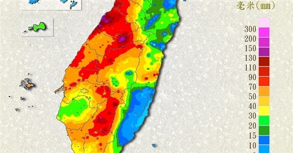
(CNA, Taipei, June 9) The Central Weather Administration (CWA) stated that today is the day with the most significant rainfall from the current stationary front and southwest monsoon. The public in southern mountainous areas should be aware of continuous precipitation, and watch out for torrential rain in the mountain areas of Kaohsiung and Pingtung. As of 3:30 PM, the cumulative rainfall was highest in Liugui District, Kaohsiung City, at 216.5 mm.
The Ministry of Transportation and Communications' Central Weather Administration has activated its "enhanced operations for relatively large-scale or severe torrential rain events" in response to the "0608 stationary front and southwest monsoon torrential rain event."
Wu Wan-hua, deputy director of the CWA's Weather Forecast Center, stated in a press conference this afternoon that a stationary front is currently over Taiwan, with convective cloud systems continuing to develop on the frontal boundary, bringing abundant moisture with the southwest monsoon. The western half of Taiwan and Penghu are still experiencing intermittent showers, with localized short-duration heavy rainfall.
Wu pointed out that southern mountainous areas must be aware of continuous heavy rainfall caused by topographic effects, and that localized heavy or torrential rain cannot be ruled out in the mountain areas of Kaohsiung City and Pingtung County. For the next 18 hours or so, vigorous convective cloud systems will continue to affect Taiwan, with rainfall persisting from this afternoon to early tomorrow morning in the western half, the northeast, and the mountainous areas of Hualien and Taitung.
Regarding the weather for the coming week, Wu explained that the front will linger north and south of Taiwan, leading to unstable weather with a high chance of showers or thunderstorms. Today is the day with the most significant rainfall. Tomorrow, the front will begin to move south, and the southwest monsoon will weaken slightly, making the rain more moderate than today. However, localized heavy rain or torrential rain is still possible in the mountainous areas of Hualien-Taitung and the central and southern regions.
Wu said that on the 11th, the front will move south to the Bashi Channel, with scattered brief showers or localized thunderstorms still occurring in various places, and localized heavy rain in the central and southern regions. Starting from the 12th, the front will move north, and localized heavy rain or torrential rain may still occur in the western half and the mountainous areas of the eastern half. The current forecast suggests this may continue to affect the region until the 15th, with rainfall intensity depending on the moisture from the southwesterly winds and the position of the stationary front.
According to the CWA website, as of 3:30 PM today, the cumulative rainfall was highest in Liugui District, Kaohsiung City, at 216.5 mm. In the period from yesterday to 3:30 PM today, the cumulative rainfall was also highest in Liugui District, Kaohsiung City, at 367 mm, followed by 283 mm in Beigang Township, Yunlin County, and 260 mm in Wanli District, New Taipei City.
Wu reminded the public that today, coastal open areas in the western half, southeast, and Hengchun Peninsula, as well as all outlying islands, are experiencing gusts of about 8 to 9 on the Beaufort scale, with nearby sea waves increasing to 2 to 3 meters. During thunderstorms, there are often sudden downpours, lightning, and strong gusts. Drivers should be mindful of low visibility and road conditions. In mountainous areas, be aware of softened soil, landslides, collapses, rockfalls, debris flows, and flash floods in streams, and avoid going to these areas. Low-lying areas should be on alert for flooding.
FACT BOX
- Source: CNA (Central News Agency)
- Category: 事件