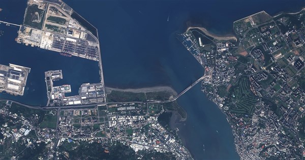
The first 'Zeppelin' satellite of 'Formosat-8,' Taiwan's premier self-developed satellite constellation, entered orbit last November and commenced its official imaging mission this January. Today, the National Space Organization (TASA) released 15 images of Taiwan, featuring the Taipei and Danjiang Bridges, Taoyuan Aerotropolis, Cingshuei Cliff, and the future National Launch Site at Jiupeng, allowing the public to see Taiwan from a new perspective.
Formosat-8 is Taiwan's first indigenous optical remote sensing satellite constellation. Its first satellite (FS-8A) was named 'Zeppelin' to carry on the spirit of the late director Chi Po-lin in guarding Taiwan, with the hope that the Zeppelin satellite will watch over and document Taiwan from space. After its launch last November, the satellite began its formal imaging mission in January and released its first batch of images in February. Today, TASA has unveiled a new wave of imaging results.
The 15 images released by TASA span from the Port of Taipei and Port of Taichung to the Port of Kaohsiung, clearly identifying pier configurations, container yards, and large vessels. Familiar landmarks such as the Danjiang Bridge, MITSUI OUTLET PARK Taichung Port, and the Great Harbor Bridge next to the Pier-2 Art Center can also be found. In the image of the Changhua Coastal Industrial Park, even the specific patterns on the solar panels are clearly visible.
TASA pointed out that in the Taoyuan Aerotropolis image, the bright orange boarding bridges of Taoyuan International Airport's Terminal 3 are unmistakable. For those who have flown out of Taoyuan, the view of the surrounding ponds is a familiar sight, and this unique landscape has been fully captured by the satellite. The planned National Launch Site in Pingtung's Jiupeng village is also included in this release.
TASA explained that images of outlying islands like Penghu, Little Lanyu, and Guishan Island reveal coastlines, variations in water color, and rich topographical textures. Upon closer inspection of the Penghu image, neatly arranged shallow-sea oyster racks and fishing nets can be discerned. Furthermore, images of Cingshuei Cliff, the Siaolin Village ruins, and the Taimali River mouth show geomorphological changes left by the 403 earthquake and Typhoon Morakot.
TASA stated that the greatest enemy of optical remote sensing satellites is cloud cover, especially in northeastern Taiwan where it is often cloudy, making it difficult to capture a clear sky. For instance, the image of the Xiuguluan River perfectly caught a layer of cotton-like clouds. However, the Zeppelin satellite has a daily revisit capability, providing a chance to pass over the same area every day, which greatly increases the opportunity to capture cloud-free images compared to the past.
TASA noted that since these images were taken during winter, Taiwan's relatively dry season, one can see that in the wide river channels, the actual water flow is comparatively small, exposing large areas of the riverbed. Through long-term continuous observation, it's possible to record environmental changes across different seasons and weather conditions. In the future, these images will be widely applied in fields such as national land planning, disaster relief, environmental monitoring, agricultural management, and marine observation, becoming a vital source of information for protecting Taiwan.
FACT BOX
- Source: CNA (Central News Agency)
- Category: 事件