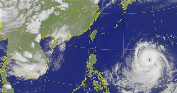
(Central News Agency, Taipei, July 7) The Central Weather Administration stated this evening that most international forecasts predict Typhoon Bavi will pass northeast of Taiwan and then turn north, with the highest probability. It is estimated that sea and land typhoon alerts will be issued consecutively on the 9th, and the storm radius of Bavi will touch Taiwan's land around the evening of the 10th.
According to the Central Weather Administration's typhoon information, Typhoon Bavi's center was located about 1930 kilometers east-southeast of Eluanbi at 2 p.m. today, moving west at 25 kilometers per hour, then turning northwest. The maximum wind speed near the center is 58 meters per second, with a 7-level wind radius of 350 kilometers and a 10-level wind radius of 150 kilometers.
CWA forecaster Huang En-hung told CNA that Bavi is currently moving steadily westward and is expected to turn north starting tomorrow. Its intensity will slightly weaken when it approaches Taiwan, but it will still affect Taiwan as a strong typhoon or the upper limit of a medium typhoon, with a storm radius still exceeding 300 kilometers.
Huang En-hung pointed out that according to current path predictions, Bavi will be closest to Taiwan on the 10th and 11th, moving north from the waters northeast of Taiwan. It will begin to move away on the evening of the 11th. The CWA expects to issue a sea typhoon alert around noon on the 9th, a land alert late on the 9th, and the storm radius of Bavi will touch Taiwan's land around the evening of the 10th.
Huang En-hung indicated that although Bavi will pass through the sea northeast of Taiwan, it is still slightly different from traditional northwest typhoons. The main difference is that Bavi will continue to turn north, and coupled with its fast speed, it means the impact on Taiwan will be relatively short-lived.
Huang En-hung mentioned that due to Bavi's intact structure, even if its storm radius is potentially damaged as it approaches Taiwan, northern and Yilan areas, as well as mountainous areas in central and southern Taiwan, will still experience heavy rain or torrential rain on the 10th and 11th. Torrential rain or above is possible in mountainous areas north of Taichung.
Huang En-hung further explained that as Bavi approaches, current forecasts predict that northern and Yilan areas will gradually experience intermittent showers starting the daytime of the 10th, with wind and rain gradually increasing. The wind and rain will be strongest from the evening of the 10th to the daytime of the 11th. By the evening of the 11th, as Bavi gradually moves away, the rainfall will begin to ease.
However, Huang En-hung said that on the 12th, moisture will still be abundant, with winds shifting to the south. Intermittent showers are expected mainly in western and southeastern Taiwan. On the 13th and 14th, Hualien, Taitung, and the Hengchun Peninsula will have localized intermittent showers, while other areas will be mostly cloudy with a chance of brief thunderstorms in the afternoon.
Regarding temperatures, Tainan should still be aware of localized high temperatures above 38 degrees Celsius tomorrow. Greater Taipei, areas south of Taichung, and Yilan and Hualien should also be aware of temperatures reaching above 36 degrees Celsius. Additionally, from tomorrow until the 12th, long waves are expected along the Keelung North Coast, the eastern coast (including Green Island and Orchid Island), the Hengchun Peninsula, and Matsu. (Editor: Chen Ching-fang) 1150707
Stand with facts, and your every donation is a force to protect the freedom of the press
Download the CNA "One-Stop News" APP to get the latest news in real time
The text, images, and videos on this website may not be reproduced, publicly broadcast, or publicly transmitted and used without authorization.
FACT BOX
- Source: CNA (Central News Agency)
- Category: 自然災害