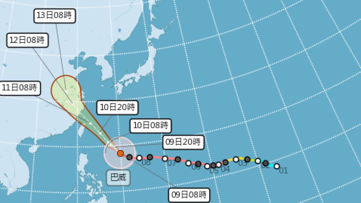
Typhoon Bavi is intensifying as it approaches Taiwan. Meteorologist Lin De-en warned on Facebook that due to an eyewall replacement cycle, Bavi’s wind field is expanding again, making it the largest typhoon under warning in the past 25 years. The fan page 'Taiwan Typhoon Forum | Weather Emergency' also shared a detailed timeline of rain and wind across Taiwan, stating that given Bavi’s strength, it could be the most impactful typhoon for northern Taiwan in recent years.
Regarding Bavi’s structure, Lin explained that the ongoing eyewall replacement is causing the storm’s gale-force wind radius to expand. Current data shows the radius of 7-level winds has reached 380 kilometers, while 10-level winds extend up to 180 kilometers—both figures ranking as the largest among typhoons with issued warnings in the past 25 years. While size doesn’t always equate to strength, Bavi is currently tied as the strongest typhoon in the Northwest Pacific this year.
The 'Weather Emergency' page emphasized that Bavi could be the closest Taiwan has come in over a decade to experiencing a true 'northwest typhoon.' With a record 380-kilometer gale radius, the storm will significantly affect all regions of Taiwan.
Based on the latest Central Weather Bureau forecast, here is the expected impact timeline:
- Northern Taiwan: Regardless of landfall, the typhoon’s core will pass directly over northern skies. Given its intensity, this could be the most impactful typhoon for the north in years. From the daytime on the 10th, outer circulation will bring intermittent rain and wind. Conditions will worsen at night, with the 11th expected to bring continuous heavy rain and strong winds—preparations for torrential rainfall are essential.
- Central and Southern Lowlands, Penghu Islands: Due to Bavi’s large size, the Central Mountain Range won’t fully block its effects. Winds will wrap around the island and hit the western half. Strong gusts will begin on the 10th, peaking on the 11th with wind speeds reaching Category 10 or higher. Intermittent rain will start late on the 10th, and as the storm passes northern Taiwan on the 11th, central and southern regions will shift to the windward side, increasing rainfall.
- Mountainous Areas in Central and Southern Taiwan: Minimal impact before the 10th. However, once the storm crosses northern Taiwan on the 11th, these areas will become windward, leading to significantly heavier rain. Forecasted rainfall is substantial—preparations for heavy downpours are advised.
- Yilan and Northern Hualien: As the first line of impact, intermittent rain and wind will begin on the 10th, intensifying through the night and peaking on Saturday morning. Yilan is particularly at risk—if Bavi makes landfall, it’s most likely here. Direct eyewall contact would bring extreme winds and rain. However, landfall may only be confirmed when the storm is very close, so vigilance is crucial throughout.
- Southern Hualien and Taitung: These areas will see relatively less impact due to mountain shielding. However, foehn winds may occur on the morning of the 11th, causing extreme heat, especially in the Huadong Valley. In the afternoon, as winds shift to southerly, coastal areas of Taitung will experience increased rain and wind.
- Kinmen and Matsu: Kinmen is farther from the storm and will see minimal impact, mainly from outer rain bands. Matsu, however, could be directly hit by the storm’s core, with strong winds and heavy rain expected from the 11th to the 12th.
FACT BOX
- Source: PR Times
- Category: News