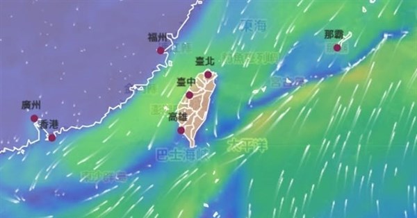
(CNA Website) A "mysterious blue line" that has recently appeared frequently near Taiwan on wind forecast charts has sparked public curiosity. The Central Weather Administration explained in a Facebook post that this blue line is actually a "front," a location where winds from different directions converge.
The administration pointed out that according to the legend on the right, the dark blue and purple colors represent weak horizontal wind speeds, so the blue line signifies a long, narrow "low-wind-speed zone." In this chart, the north side of the front has cooler northeasterly winds, while the south side has the southwesterly monsoon carrying large amounts of warm, moist air. When the two air currents meet here, they must "brake suddenly," forming a low-wind-speed zone where the wind speed approaches zero.
However, the airflow does not simply disappear. When two powerful air currents collide horizontally, they are forced to rise, sending moisture high into the atmosphere, which then develops into vigorous convection and brings rain. Therefore, the weather near the frontal zone represented by this blue line is usually more unstable and is a hot zone for intense convective rainfall.
The administration stated that this airflow convergence line tends to appear near Taiwan in May and June each year, which is the stationary front often heard about recently. The administration reminds the public to remember to bring rain gear when they see this keyword and to pay attention to alerts issued by the Weather Administration. (Editor: Wang Chia-yu) 1150610
FACT BOX
- Source: CNA (Central News Agency)
- Category: 社會
- Dates in source: 1150610