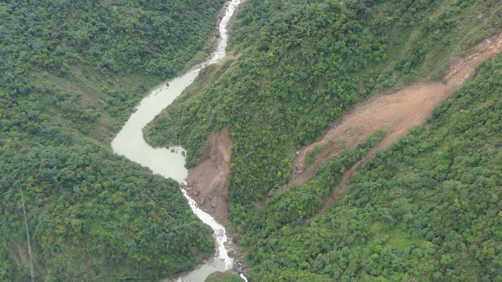
(Central News Agency reporter Hsiao Po-yang, Nantou County, June 16) A landslide occurred on the left bank of Chajiaoliao Creek, a tributary of Qingshui Creek in Zhushan Township, blocking the river channel and forming a barrier lake. The Rural Development and Water Conservation Agency stated today that the risk of another large-scale collapse is low. If the lake were to breach all at once, downstream water levels would rise by approximately 70 centimeters, and the overall risk remains within a manageable range.
Affected by the heavy rainfall on June 8 ('0608 torrential rain'), a slope collapsed upstream of the Ruilong Waterfall Park area in Zhushan Township along Chajiaoliao Creek (a tributary of Qingshui Creek). On the 13th, residents discovered that the river channel had been blocked by accumulated soil and rock, forming a barrier lake, and reported it to the Nantou County Government. The Council of Agriculture's Rural Development and Water Conservation Agency has completed on-site inspections, and Director Chen Chun-yen visited the site today to assess the current situation, monitoring operations, and emergency response measures.
Director Chen stated that in the face of compound disasters caused by extreme climate, the principle of 'broad anticipation, strict defense' must be upheld. The agency must continuously monitor changes in the barrier lake and remain vigilant despite the currently low risk. The Rural Development and Water Conservation Agency has established an emergency response team according to its barrier lake management protocol and maintains close communication with the Nantou County Government to jointly monitor on-site conditions and ensure public safety.
Chen added that on-site inspections and risk assessments have been completed, and 24-hour monitoring measures have been activated, including setting up mobile surveillance camera stations, conducting regular drone aerial surveys, monitoring downstream water levels, and on-site patrols. These technological monitoring efforts allow real-time tracking of changes in the barrier lake's water level, dam structure, and river channel, providing critical data for future disaster prevention and emergency decisions.
In a press release, the agency stated that the Nantou County Government has placed warning signs in hazardous areas around Chajiaoliao Creek, advising the public not to enter the river or surrounding areas for fishing, swimming, or river trekking. The government continues to collaborate with local authorities, village chiefs, disaster prevention officers, and relevant agencies to monitor changes. Any anomalies will trigger immediate emergency responses and public information releases to fully protect lives and property.
The agency reported that the landslide area is approximately 1.2 hectares, with an accumulation volume of 50,000 cubic meters and an upstream water storage capacity of 100,000 cubic meters. The barrier lake has naturally begun to overflow, carving out a water channel. Water levels and river conditions remain stable. Assessments indicate that the collapsed slope has reached the bedrock layer, reducing the likelihood of another large-scale collapse. In the event of a sudden breach, water levels are estimated to rise by about 70 cm. Currently, there are no protected households downstream, and the Ruilong Waterfall suspension bridge is not directly affected. Therefore, the overall risk remains within a manageable range. (Editor: Chen Jen-hua) 1150616
FACT BOX
- Source: CNA (Central News Agency)
- Category: Taiwan