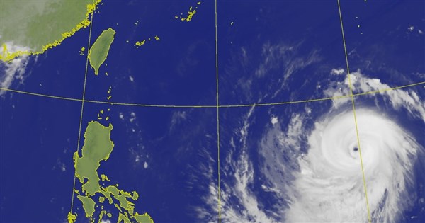
(CNA) - The Central Weather Administration (CWA) has issued a high-temperature advisory for 11 counties and cities, including New Taipei, warning of temperatures reaching 36 degrees Celsius today. Weather expert Wu Der-rong stated that Typhoon Bewa is approaching, and strong winds and heavy rain are expected to rapidly increase across the island on July 10. Residents should be wary of destructive strong winds and torrential downpours. From July 12 to 15, as Bewa moves away, attention should still be paid to strong afternoon rainfall.
The CWA announced a high-temperature advisory today, citing the influence of the Pacific high-pressure system, which is causing hot and sunny weather across the island. Today, New Taipei City, Changhua County, Yunlin County, Chiayi City, Tainan City, Kaohsiung City, Pingtung County, and Hualien County are under an orange alert, warning of continuous temperatures of 36 degrees Celsius. Taichung City, Nantou County, and Chiayi County are under a yellow alert, cautioning against temperatures exceeding 36 degrees Celsius.
Wu Der-rong, an adjunct associate professor at National Central University's Department of Atmospheric Sciences, stated in a column on the "Sky Leakage Classroom" platform of the Weather Promotion Foundation today that the latest European model simulations indicate that from today until July 9, the Pacific high-pressure system will influence the weather, resulting in sunny to cloudy skies with localized brief showers in mountainous areas in the afternoon. Today's heat will be like midsummer, with the highest temperatures across Taiwan potentially reaching around 38 degrees Celsius, requiring attention to sun protection and heatstroke prevention.
Wu Der-rong noted that the latest model simulations show that on July 10 and 11, Typhoon Bewa will affect the island, and residents should be cautious of "disaster-causing" strong winds and heavy rain. On July 10, winds and rain will rapidly increase across the island. By the evening of July 11, the winds and rain on the main island will begin to subside. From July 12 to 15, Bewa will have moved away, but due to the southerly winds and residual moisture, the atmosphere will remain unstable, with occasional localized showers and frequent strong convective activity in the afternoon, accompanied by lightning, strong winds, and sudden heavy rainfall. Caution is still advised.
Wu Der-rong pointed out that the latest CWA typhoon track forecast map shows that Typhoon Bewa, the ninth typhoon of the season, continues to move northwest-west. On July 9, it will be located south of the Ryukyu Islands and gradually turn northwest. On July 11 and 12, its center is forecast to pass near the northeast coast of Taiwan and the northern sea, before making landfall at the border of Zhejiang and Fujian provinces. However, the uncertainty range includes areas from Miyako Island to the entire island of Taiwan.
Wu Der-rong said that the latest European model ensemble simulation map shows that Bewa's path is slightly shifted southward, with a higher probability of its center passing near or over the northern coast or land of Taiwan. The path uncertainty includes deviations to the north, passing Miyako Island, or to the south, making landfall in the east. Depending on the different paths, the intensity of winds and rain across various regions will vary significantly, but none should be underestimated. The approaching typhoon means business, and preparations should be made early. (Edited by Chen Ren-hua) 1150707
Stand with facts. Your every donation is a force to protect press freedom.
Download the CNA "First News" APP to get the latest news in real-time.
Text, images, and videos on this website may not be reproduced, publicly broadcast, or publicly transmitted and used without authorization.
FACT BOX
- Source: CNA (Central News Agency)
- Category: 天氣預報