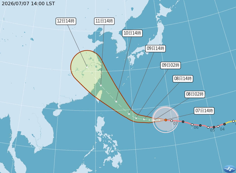
(CNA reporter Chang Hsiung-feng, Taipei, July 7) Super Typhoon Bavi is approaching, and the Central Weather Administration (CWA) said today that it has prepared disaster scenarios for landfall or not. If the typhoon does not make landfall, rainfall will be concentrated in the mountainous areas north of central Taiwan; if it makes landfall, rainfall in the mountainous areas across Taiwan will be considerable. Currently, forecasts from various countries indicate the highest probability of it passing through the waters northeast of Taiwan.
According to the CWA's typhoon information, Super Typhoon Bavi's center was located approximately 1930 kilometers east-southeast of Eluanbi at 2 PM today, moving west then west-northwest at a speed of 25 kilometers per hour. The maximum sustained wind speed near the center is 58 meters per second, with a 7-grade wind radius of 350 kilometers and a 10-grade wind radius of 150 kilometers.
Premier Cho Jung-tai visited the CWA this afternoon to inquire about the situation of Super Typhoon Bavi. He stated that Bavi is approaching with great force, and the government dare not be complacent. Whether it passes through the northern sea or makes landfall, it poses a significant threat to Taiwan. He called for the nation to enter a state of high alert and urged local governments to strengthen their preparedness.
Cho Jung-tai said that the deployment of military forces will focus on Hualien and Taitung as the primary areas, hoping they can be effective in a timely manner if needed.
Cho Jung-tai mentioned that the heavy rainfall event on June 25th caused work and school suspensions in 10 counties and cities, and areas that had not flooded for a long time experienced flooding. He called on all counties and cities to conduct another thorough inspection to completely eliminate the causes of the previous flooding, and even to expand the scope of cleaning and patrols to conduct a comprehensive and effective inspection.
Cho Jung-tai also appealed to the public, stating that during this time, activities such as watching waves and hiking must absolutely be prohibited. Self-discipline is essential to avoid adding burdens to the rescue and work efforts of all teams in local governments.
CWA Director-General Chen-Chung Wu explained the typhoon's dynamics, stating that Bavi is strong with a wide radius of storm winds, posing a significant threat to Taiwan. Forecasts from various countries indicate the highest probability of it passing through the waters northeast of Taiwan, but given the current distance, the margin of error still leaves the possibility of landfall in Taiwan. It is currently expected that a sea warning will be issued on the afternoon of the 9th, and a land warning will be issued on the evening of the 9th to the 10th.
In response, the CWA has prepared two disaster scenarios: one where it passes through the northern sea area of Taiwan, and another where it makes landfall on the northeast coast. Chen-Chung Wu pointed out that the forecasts also reference past typhoon data, including Typhoon Lekima (2019, did not make landfall) and Typhoon Soulik (2012, made landfall).
Firstly, if Bavi passes through the northern sea area of Taiwan as expected, the affected area will be concentrated in the north, with rainfall most significant in the mountainous areas of Taoyuan, Hsinchu, and Miaoli, accumulating approximately 500 to 800 millimeters of rain north of central Taiwan; the Matan Creek watershed in Hualien, being on the leeward side, will receive about 100 to 200 millimeters of rain. However, if it makes landfall around Yilan, rainfall in all mountainous areas will reach 500 to 800 millimeters, and Matan Creek may receive 150 to 300 millimeters of rain.
Overall, Chen-Chung Wu stated that the current forecast indicates the main areas of heavy rainfall will be in the mountainous regions north of Taichung, where heavy to extremely heavy rainfall is likely.
Regarding wind force, Chen-Chung Wu said that regardless of the scenario, coastal areas will experience gusts of 6 to 10 grades. If the typhoon makes landfall, inland areas may also experience strong gusts. He specifically warned that during the typhoon's impact period, coastal areas of the north and northeast, as well as Matsu and Lanyu, may experience strong gusts of 10 to 12 grades or higher.
Chen-Chung Wu reminded the public that during the typhoon's impact period on the 10th and 11th, coastal areas will experience long waves of 6 meters or more. The CWA will use cell broadcast notifications to alert residents near the coast; it is estimated that the wind and waves will gradually weaken by the afternoon of the 12th. (Editor: Li Shu-hua) 1150707
Stand with facts, your every donation is a force to protect press freedom
Download the CNA "First Hand News" APP to get the latest news in real-time
This website's text, images, and videos may not be reproduced, publicly broadcast, publicly transmitted, or used without authorization.
FACT BOX
- Source: CNA (Central News Agency)
- Category: 自然災害