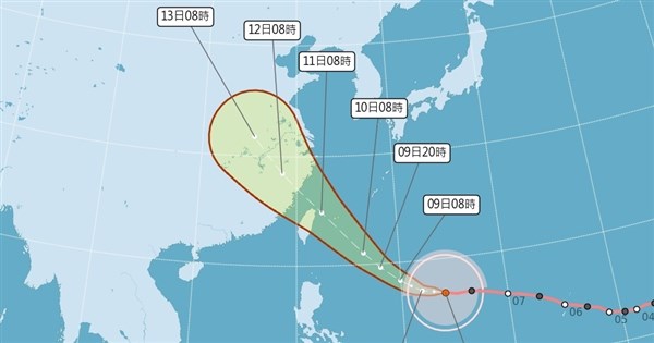
(Central News Agency, reporter Zhang Xionfeng, Taipei, August 8) The Central Weather Administration (CWA) stated that Bavi remains a super typhoon with a storm radius of 380 kilometers, making it both strong and large. Currently, the highest probability forecast is for it to pass by the waters northeast of Taiwan, but a closer approach to Taiwan cannot be ruled out due to interactions with topography.
According to the CWA's typhoon information, as of 8 AM today, Super Typhoon Bavi had a central pressure of 895 hPa, with its center located approximately 1490 kilometers east-southeast of Eluanbi. It is moving westward at 21 kilometers per hour, turning northwest-west. The maximum sustained wind speed is 60 meters per second, with a 7-level wind radius of 380 kilometers and a 10-level wind radius of 180 kilometers.
CWA forecaster Ye Zhi-jun stated at a weather briefing this morning that if Bavi follows its current predicted path, a marine typhoon warning could be issued as early as tomorrow afternoon, and a land typhoon warning could be issued from tomorrow night to early the morning of the 10th. Starting tomorrow evening, the outer circulation of the typhoon will begin to affect Taiwan, with rainfall gradually increasing in areas north of Taoyuan and Yilan, which are on the windward side.
Ye Zhi-jun mentioned that today's sea and atmospheric conditions are favorable, and Bavi's intensity and size will remain. Starting tomorrow, its intensity will gradually weaken, but it will still be at the lower end of a super typhoon or the upper end of a typhoon when it affects Taiwan. Currently, the highest probability forecast is for it to pass by the waters northeast of Taiwan, but a closer approach to Taiwan cannot be ruled out due to interactions with topography.
Ye Zhi-jun pointed out that the period from the evening of the 10th to the 11th will be the most significant impact period. As it passes by the waters northeast of Taiwan, heavy rain or torrential rain may occur in areas north of central Taiwan, Yilan, and mountainous areas of southern Taiwan and Hualien. Mountainous areas in northern Taiwan may experience rainfall of torrential rain or higher.
Ye Zhi-jun further explained that during the day on the 10th, the winds around Taiwan will be mainly northeasterly. Rainfall will gradually increase and winds will significantly strengthen in northern Taiwan and Yilan starting during the day. From the evening of the 10th to the 11th, as Bavi moves to the northeast sea and heads north, the winds around Taiwan will shift to northwesterly, and then later to westerly to southwesterly. Areas north of central Taiwan, Yilan, and mountainous areas of southern Taiwan and Hualien will experience heavy rain or torrential rain, with mountainous areas in northern Taiwan potentially experiencing rainfall of torrential rain or higher.
Ye Zhi-jun said that starting from the 12th, Bavi will gradually move away, and the environment around Taiwan will shift to a southerly wind. Moisture will still be abundant, and western and central Taiwan may experience intermittent brief showers or thunderstorms. On the 13th and 14th, the Pacific high-pressure system will extend westward, and the wind direction will shift to southeasterly, leading to stable weather mainly characterized by afternoon thunderstorms. Mountainous areas should still be cautious of localized heavier rainfall.
Ye Zhi-jun stated that waves of up to 2 meters have already been observed in Lanyu. Starting tomorrow, wave heights in the seas north of Taiwan, east of Taiwan, and the Bashi Channel will reach 2 meters or more. East coast areas may even experience large waves of 3 to 4 meters. During the typhoon's impact, coastal areas of northern and eastern Taiwan and Matsu may experience giant waves of 6 meters or more.
Ye Zhi-jun reminded that Bavi will pass by the waters northeast of Taiwan from the evening of the 10th to the 11th. Due to its size and strength, the wind and rain will be quite significant. Preparations for the typhoon should be made regardless of whether it is a northwestward-moving typhoon. (Editor: Li Hengshan) 1150708
Stand with facts, your every donation is a force to protect the freedom of the press
Download the CNA "One-Stop News" APP for real-time updates
The text, images, and videos on this website may not be reproduced, publicly broadcast, publicly transmitted, or used without authorization.
FACT BOX
- Source: CNA (Central News Agency)
- Category: 自然災害