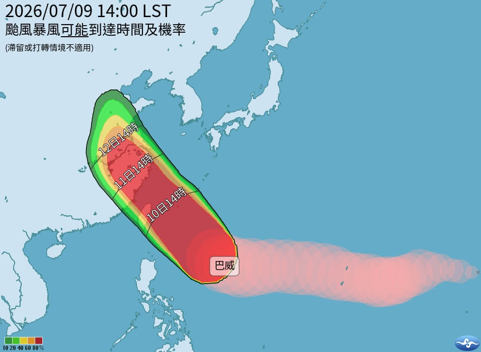
(Central News Agency, reporter Zhang Xiongfeng, Taipei, September 9) Strong typhoon Bavi continues to approach Taiwan, with giant waves of 7 meters already observed in Taitung and Lanyu. The Central Weather Administration estimates that a land warning will be issued as early as tomorrow morning.
The Central Weather Administration issued a sea typhoon warning for Typhoon Bavi this afternoon. At 5 p.m., the center of Bavi was located about 870 kilometers east-southeast of Eluanbi, moving north-northwest to northwest at a speed of 17 to 25 kilometers per hour. The central pressure was 925 millibars, with maximum sustained winds near the center at 51 meters per second, and a storm radius of 380 kilometers for seven-level winds and 180 kilometers for ten-level winds.
The sea warning area includes the waters northeast of Taiwan, the waters southeast of Taiwan (including Lanyu and Green Island), and the Bashi Channel.
Weather forecaster Xie Peiyun stated at a typhoon press conference this evening that Typhoon Bavi will gradually move northwest, approaching the waters east of Taiwan tomorrow afternoon, and passing through the waters north of Taiwan tomorrow night to the 11th. However, due to the influence of terrain, there may be some north-south oscillation in its path as it approaches Taiwan, and the possibility of landfall cannot be completely ruled out.
Xie Peiyun emphasized that Bavi is a very large typhoon and will have a significant impact on Taiwan regardless of whether it makes landfall. Tomorrow night to the 11th will be the period of most intense impact from Bavi on Taiwan. A land typhoon warning is predicted to be issued between tomorrow early morning and dawn.
Xie Peiyun explained that intermittent rain and wind will become more frequent starting tomorrow daytime, becoming more pronounced later in the day, mainly affecting northern and northeastern Taiwan, with significant convective development also expected in the mountainous areas of central and southern Taiwan. Tomorrow night to the 11th, rainfall will be most intense in northern Taiwan, and the mountainous areas of central and northeastern Taiwan, with potential for rainfall exceeding the torrential rain level. Other areas may also experience torrential rain or heavy rain.
Xie Peiyun reminded that from tonight to tomorrow, all areas except Nantou County and Chiayi City should be aware of average winds of level 6 or gusts of level 8 or higher. Tomorrow night to the 11th, all parts of Taiwan and its outlying islands may experience strong gusts of level 9 to 11, with gusts of level 12 or higher possible in the areas north of Taoyuan, Yilan, Lanyu, and Green Island.
Xie Peiyun pointed out that giant waves of 7 meters have already been observed in Taitung and Lanyu. From tonight to tomorrow, long waves are likely to occur along the coasts of northern and eastern Taiwan (including Lanyu and Green Island), the Hengchun Peninsula, and Matsu. Winds and waves in the waters around Taiwan will gradually increase to over 3 meters, with giant waves of over 6 meters particularly likely along the coasts of eastern Taiwan and the Hengchun Peninsula. (Editor: Zhang Yajing) 1150709
Stand with the facts. Your every donation is a force to protect press freedom.
Download the CNA "One-Stop News" APP for real-time updates.
The text, images, and videos on this website may not be reproduced, publicly broadcast, publicly transmitted, or used without authorization.
FACT BOX
- Source: CNA (Central News Agency)
- Category: 自然災害