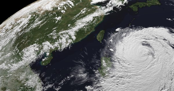
(CNA, Taipei, July 9) The Central Weather Administration today issued a strong typhoon marine warning for Typhoon Bavi, cautioning of threats to the Bashi Channel, and the southeastern and northeastern sea areas. The storm's radius is expected to begin affecting Taiwan tomorrow, with coastal areas experiencing gusts of level 8 to 9, or even level 10, during the day. The most severe winds and rain are anticipated from tomorrow evening through the 11th.
The CWA issued the Bavi marine typhoon warning at 2:30 PM.
The Central Weather Administration of the Ministry of Transportation and Communications stated that at 2 PM, the center of strong Typhoon Bavi was located approximately 920 kilometers east-southeast of Eluanbi, moving north-northwest then northwest at a speed of 20 to 23 kilometers per hour. The central atmospheric pressure was 925 millibars, with a maximum sustained wind speed near the center of 51 meters per second. The radius of seven-level winds was 380 kilometers, and the radius of ten-level winds was 180 kilometers.
CWA forecaster Lin Po-tung said at a typhoon warning press conference this afternoon that Typhoon Bavi's storm radius is expected to gradually affect Taiwan starting tomorrow, with the period from tomorrow evening to the 11th being the most significant impact.
Lin Po-tung pointed out that current sea and air conditions are unfavorable for Bavi, causing a slight weakening, but it remains a strong typhoon with a storm radius of 380 kilometers. Bavi continues to approach Taiwan today and will pass north of Taiwan tomorrow afternoon. Due to interaction with Taiwan's landmass, its path might shift further north, or it could move closer to Taiwan. It is projected to gradually move away from Taiwan on the 12th.
Regarding wind intensity, Lin Po-tung stated that coastal areas nationwide will experience gusts of level 8 to 9, or even level 10, tomorrow during the day. From tomorrow evening to the daytime of the 11th, all areas will experience gusts of level 9 to 11, with particularly strong winds in areas north of Taoyuan, Yilan, Matsu, Lanyu, and Green Island. The winds will slightly weaken on the evening of the 11th and will subside on the 12th as the typhoon moves away.
Lin Po-tung said that rainfall will be significant from tomorrow evening to the daytime of the 11th. On the daytime of the 10th, rainfall will intensify in northern and northeastern Taiwan, with heavy or torrential rain possible. From tomorrow evening to the 11th, rainfall will be most pronounced, with potential for torrential rain or higher in northern Taiwan and mountainous areas of central Taiwan and Yilan. Although the typhoon will move away and winds and rain will lessen on the 12th, intermittent showers should still be expected in all areas.
Lin Po-tung warned that waves of 6 meters have already been observed in Taitung. Today and tomorrow, long waves are likely along the coasts of northern and eastern Taiwan (including Lanyu and Green Island), the Hengchun Peninsula, and Matsu. Wave heights in the waters near Taiwan will gradually increase to over 3 meters, with particularly large waves of over 6 meters expected along the coasts of eastern Taiwan and the Hengchun Peninsula. (Editor: Kuan Chung-wei) 1150709
Stand with facts, your every donation is a force to protect press freedom
Download the CNA "First News" APP to get the latest news in real time
Text, images, and videos on this website may not be reproduced, broadcast, transmitted, or used without authorization.
FACT BOX
- Source: CNA (Central News Agency)
- Category: 自然災害