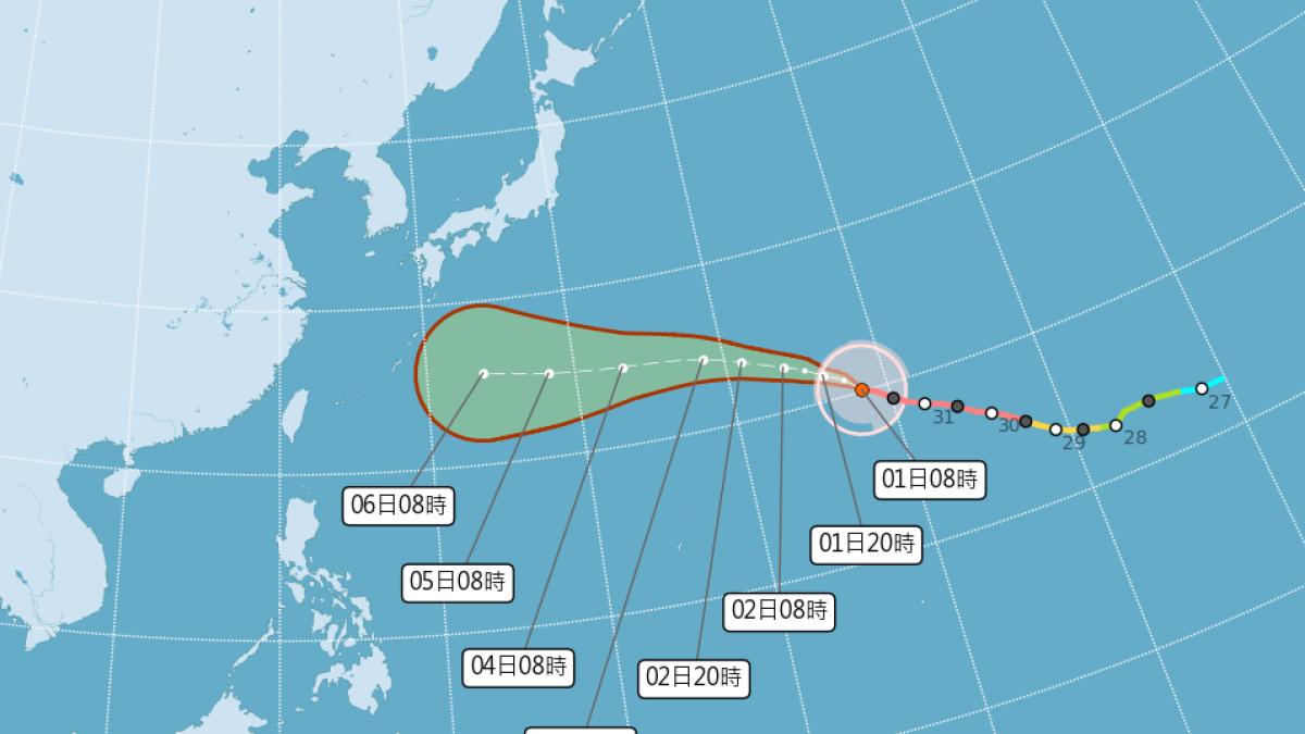
Super Typhoon Bailu continues to churn in the Northwest Pacific, currently undergoing an eyewall replacement cycle. Its overall structure has slightly deteriorated, but environmental conditions over the next 12 to 24 hours remain highly favorable. If the replacement completes successfully, a temporary reintensification cannot be ruled out. Forecast models diverge on its later track, but most agree Bailu will approach the waters near the Ryukyu and Okinawa islands between August 6 and 7. Whether it then turns northward or continues westward remains uncertain.
According to data from the Central Weather Administration at 8:00 AM on August 1, Bailu's center was located at 20.1 degrees north latitude and 158.3 degrees east longitude, moving northwest at 24 km/h. The central pressure is 915 hPa, with maximum sustained winds of 53 m/s and gusts up to 65 m/s. The radius of gale-force winds (7-level) averages 300 km, while the radius of storm-force winds (10-level) averages 160 km. The typhoon remains far from Taiwan and will not directly affect its weather in the short term.
Why is Bailu weakening?
The meteorological fan page 'Taiwan Typhoon Forum | Weather Emergency' notes that Bailu remains at super typhoon intensity but has slightly degraded due to eyewall replacement. The next 24 hours still offer favorable development conditions; if the replacement completes smoothly, intensity may briefly rebound. However, oceanic heat content will gradually decrease afterward, and vertical wind shear will increase, leading to gradual weakening after 24 hours. Still, it will maintain significant strength and a large wind field.
Another meteorological page, 'Observing Weather and Climate,' indicates satellite low-level scans already show a clear double eyewall structure, signaling the typhoon is undergoing its third eyewall replacement. The page analyzes that if the replacement succeeds, the eye diameter and wind field may expand, potentially reaching a fourth intensity peak within 36 to 48 hours. If it fails, the storm may continue weakening.
Approaching Ryukyu from August 6? Diverging paths: northward turn vs. continued westward movement
In terms of track, Bailu will move generally northwest over the next day, then shift westward as the Pacific high-pressure system re-strengthens, heading toward the Ryukyu Islands. There is consensus among models that Bailu will approach the waters near Ryukyu and Okinawa between August 6 and 7. However, subsequent movement will be influenced by the Pacific high, troughs, and other tropical disturbances, resulting in high forecast uncertainty.
Weather forecaster Cheng Chieh-jen from the Central Weather Administration stated that in the short term, Bailu will gradually approach the waters south of Japan and near the Ryukyu Islands, guided by the Pacific high. It has a 'high probability of moving westward,' though paths toward central China or the Korean-Japanese region remain possible. 'Observing Weather and Climate' warns that current models and ensembles still lack consensus on whether Bailu will turn north, move south, or continue westward, urging the public to monitor the latest forecasts.
More exclusive insights from Wind Media: · Will Super Typhoon Bailu hit Taiwan? Latest path revealed – experts highlight key observation windows · M5.6 earthquake near New Taipei's Shuangxi – CWA warns of aftershocks up to magnitude 5 in the coming week
FACT BOX
- Source: PR Times
- Category: News